Perimeter of India In Brief
Indian Perimeter
India is one of the 7th largest country in the world in terms of area after Russia, USA, Canada, China, Brazil and Australia. It consists of a total area of 3287263 square kilometers (1269219 square miles). And in terms of population, India is the 2nd largest country in the world after China, with total population of 138.72 crores.

World Map by Population
2018
The perimeter of India measures from East to West 3214 kilometers and 2933 kilometers. It consists of a frontier land of 15209 kilometers and coastline of 7516.6 kilometers. Total perimeter of India is 15106.7 kilometers running through the land boarders of 17 states.
Map


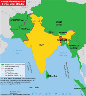
International Boarder
The Country India is situated north of the equator between 8°4' to 37°6' north latitude and 68°7' to 97°25' east longitude. Surrounded by international borders of China, Pakistan, Nepal, Bhutan, Bangladesh. Maritime boarders (Sea boarders) of Arabian Sea, Bay of Bengal, Gulf of Mannar, Indian Ocean.

Map of Maritime Boarder

Boarder Map


Comments